

Long Trail: A New Approach - Day 4

Day 4 - Thursday 7/14/2022
US-4 (104.5) to Emily Proctor Shelter (141.2)
36.7 miles / 9,810 ft gain / 7,762 loss
2.6 mph
Start: 4:36am
Finish: 6:38pm
Elapsed: 14h 02m
I took my time getting ready in the morning so I could reorganize my pack, separate my food into different bags for each day since that had been working really well so far, and simply relax and drink some coffee before starting. It's the little things! I checked out of the inn around 4:20am and walked back down the highway 0.8 miles to where I'd left off on the trail.

Gear Notes
This is the only photo I have where you can see my whole set up! Every day I wore the Tracksmith Twilight Tee (lightweight, quick drying), Tracksmith Five Lane Short Tight (lots of pockets - crucial!), and Tracksmith Session Bra (very soft and comfy). At night I wore the Franklin Quarter Snap Fleece and otherwise stuffed it in a Hyperlite bag and used it as a pillow. Tracksmith has been super supportive of my journey, if you'd like to give their gear a try, use my affiliate code for $50 off your first purchase of $150 or more.
Beyond that, I used the Pa'lante V2 Pack, Hoka Speedgoat trail running shoes (shoutout to Coach Karl aka "Speedgoat" who they're named for!), and Hiker Trash Hiker Desire Cap and Hike Trek socks (designed by "Sketch", an artist and avid hiker from Japan). Inside the bag are a smattering of things but I guess the other "big two" in addition to my pack are the Zpacks Hexamid with a groundsheet and Feathered Friends Flicker 40 UL sleeping bag.
Back to our regular programming...
Wow, I felt amazing this morning. The big meal and restful night had given me a new sort of energy. The morning coffee probably had something to do with it too. I felt happy, bubbly, and just chatted it up with other hikers on the trail. I listened to music and a podcast for the first time since starting the trail. There were far fewer hikers now since the Long Trail had finally split off from the AT.

It also helped the trail was super nice single track and just cruised along for most of the 20 miles to Brandon Gap. The miles just flew by. I felt relaxed and not rushed, and even took a nice little lunch break at Sunrise Shelter, making myself a tuna and Laughing Cow cheddar cheese wrap.
I really enjoyed the ridgeline past Brandon Gap and the Horrid Cliffs. The trail felt relatively easygoing and rolling and the weather was generally pleasant. It was getting pretty warm, however, and my water was getting low, so I took a quick detour down the Sucker Brook Shelter side trail to collect some water at a stream (it was the tiniest trickle of water, I could barely fill half my bottle because of the angle!). I'm so glad I stopped though, because little did I know that was the last water I'd see for a looong time.

The trail then wound through some ski slopes. I heard an engine and weird clanging sounds and thought, "Hmm that's weird, I didn't think I'd be close to any roads for a while." I drew closer and closer to the sound, wondering what the heck it was, then I emerged from the forest onto a ski slope meadow and suddenly a huge construction vehicle was rumbling its way right across the LT just in front of me. It was totally bizarre and jarring to see live machinery out there in what was otherwise mostly a pure nature experience.
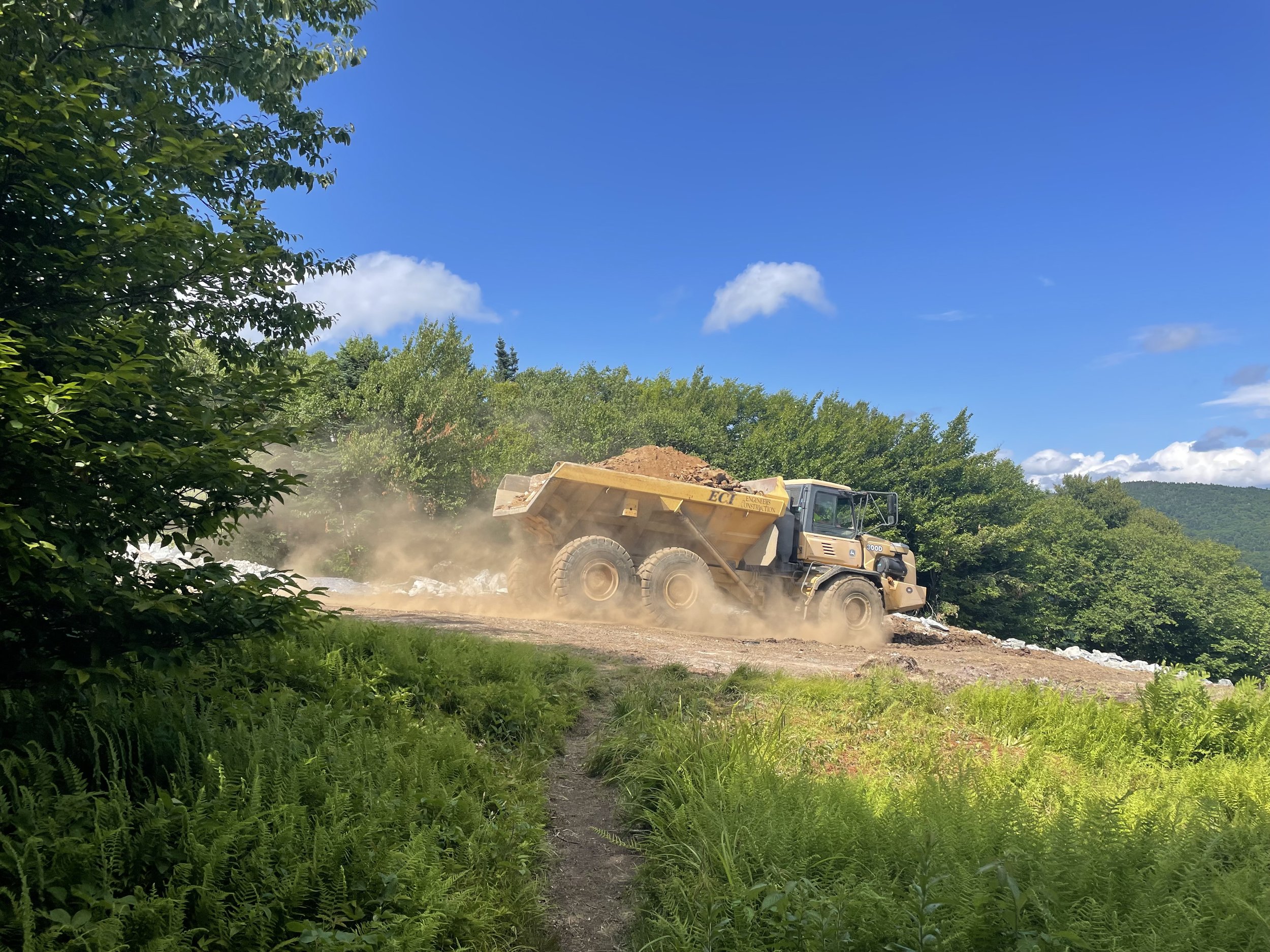
The Long Trail crossed over the same meadow several times as it zig-zagged down the slope, so I was literally following the vehicle downhill. On the last crossing, I had to pause for a second to figure out where the trail went. I waved hello to the construction worker, and he pointed across the meadow and said "The trail's that way!" Alright!

So happy!
I popped out at the next road at Middlebury Gap and entered the Breadloaf Wilderness, where I'd planned to hike to the Cooley Glen Shelter to end my day. This section proved to be way more difficult than I'd remembered. On top of being a little more technical with lots of rocks, roots, dips, and turns, this section of trail seemed to be a little less maintained than some of the other sections of the LT. Or maybe there was a recent storm, as there were quite a few blown down trees. I made okay time through this section, but found myself really huffing and puffing and starting to feel frustrated by all the little obstacles and climbing up, down, and around all the trees. Since I was higher up in elevation, the forest was very dense and the trees had stout, unbending branches that were sometimes difficult to squeeze through. I found myself getting thirsty, and my water was getting low, so I whipped out my phone to check where the next water resources were. Boyce Shelter in a few miles supposedly had a trickle of water, but unfortunately upon arrival, I found it to be mostly dried up. I collected some water from a puddle and that would have to do.

No more smooth single track for me! The beautiful and rugged Breadloaf Wilderness
My mood was starting to sour, so I paused and looked ahead on my map. My plan had been to go to Cooley Glen Shelter for a 42.9 mile day (plus the 0.8 mile early road walk). However, the next day I had "only" planned a 34.4 mile day (though that was on purpose, knowing the trail would get more difficult). Eureka! I really didn't have to go 42.9 miles, that was just my A+ plan. Really, I didn't have to do anything at all. This was my hike and I could do whatever I want. If I wanted to, I could end my day early in just a couple miles at the Emily Proctor Shelter then just add on the few miles to Cooley Glen in the morning. My next resupply was waiting for me at the Duxbury Trailhead, where I'd planned to end the next day, so I was motivated to cover the distance either way.
So that's what I decided to do. I felt weirdly guilty for deciding to end my day earlier than planned, but as I hiked on I felt better about my decision, as the next few miles continued to be frustrating and slow-going with the continuous ups, downs, and blow downs. I reached the top of Breadloaf Mountain and had to laugh at how "crumb-y" I felt on a mountain named Breadloaf. I couldn't be upset though because my day was just about done and soon I'd be able to kick back, eat dinner, and relax.

The view from Breadloaf Mountain

Emily Proctor Shelter
I had seen absolutely zero hikers since collecting water at Sucker Brook, and wasn't surprised to find the Emily Proctor Shelter totally empty. Sweet! I hopped onto the platform and started unpacking my bag, recharging my electronics, cleaning up and changing, and assembling a turkey pepperoni and cheese wrap. Just then, two young hikers arrived at the shelter. Darn. Don't get me wrong, I don't own the shelter, they had every right to it too, but I had been anticipating a quiet night alone. Oh well! The hikers were perfectly nice and polite, though they decided to make a campfire at the pit right in front of the shelter, and the wind blew all of the smoke right into the shelter as I was trying to go to sleep.
I could have easily gotten up and just set up my tent somewhere close by, but I didn't feel like it. I threw my sleeping bag over my head, put my fleece headband over my eyes, and did my best to fall asleep. I started to regret stopping early, as I could have made it to Cooley Glen with plenty of daylight still, and I might have gotten better rest there. But I had literally made my bed and was going to lie in it, darn it! I told myself to stop being a grump and curmudgeon. The boys told me they'd just finished high school two years prior, which meant they were seniors during the first pandemic spring (the same age as many of the high school students I coached in cross country and track), which had to have really sucked- they missed out on a lot of classic high school experiences like prom and graduation, not to mention likely experiencing isolation, fear, etc. all at such a young age. They told me how they'd thru-hiked the Long Trail upon graduating, which I thought was pretty cool as there are all kinds of things they could have done with their summer, and they chose to do that.
So, I didn't fall asleep as early as I would have liked, but I reminded myself that I was out there for fun and doing a really a cool thing (and so were they), and that was enough.
💫
Thanks for reading. Stay tuned for more daily recaps of the rest of my Long Trail journey right here on Mercury on the Run.
To celebrate completing my thru-hike and Long Trail Day coming up on September 10th, I'd like to give back to this trail I love so much by fundraising $2,720 for Green Mountain Club, the maintainers of the Long Trail – that's $10 for every mile of the trail! With your support I have so far fundraised $818- that's like starting from the southern terminus (mile 0) and getting all the way past White Rocks (mile 78.5) and VT Route 140 (mile 80.5)! Can you donate to support me in my goal?

I'm also working on a special Long Trail-themed project for new and continuing Buy Me a Coffee monthly members. I'm so thankful for your support and love getting to share my journey with this little community. Support me as a monthly member and not only will you get two beautiful Mercury on the Run stickers and a handwritten thanks from me, you'll receive a one-of-a-kind memento from my time here in VT.

Another great way to support is by sharing this with someone that might enjoy it too, and if you haven't already, subscribe to my weekly newsletter. 'Til next time! ~Mercury